Harlem River Greenway (Bronx) Open House Events
Round 3: Implementation Plan (Spring 2025)
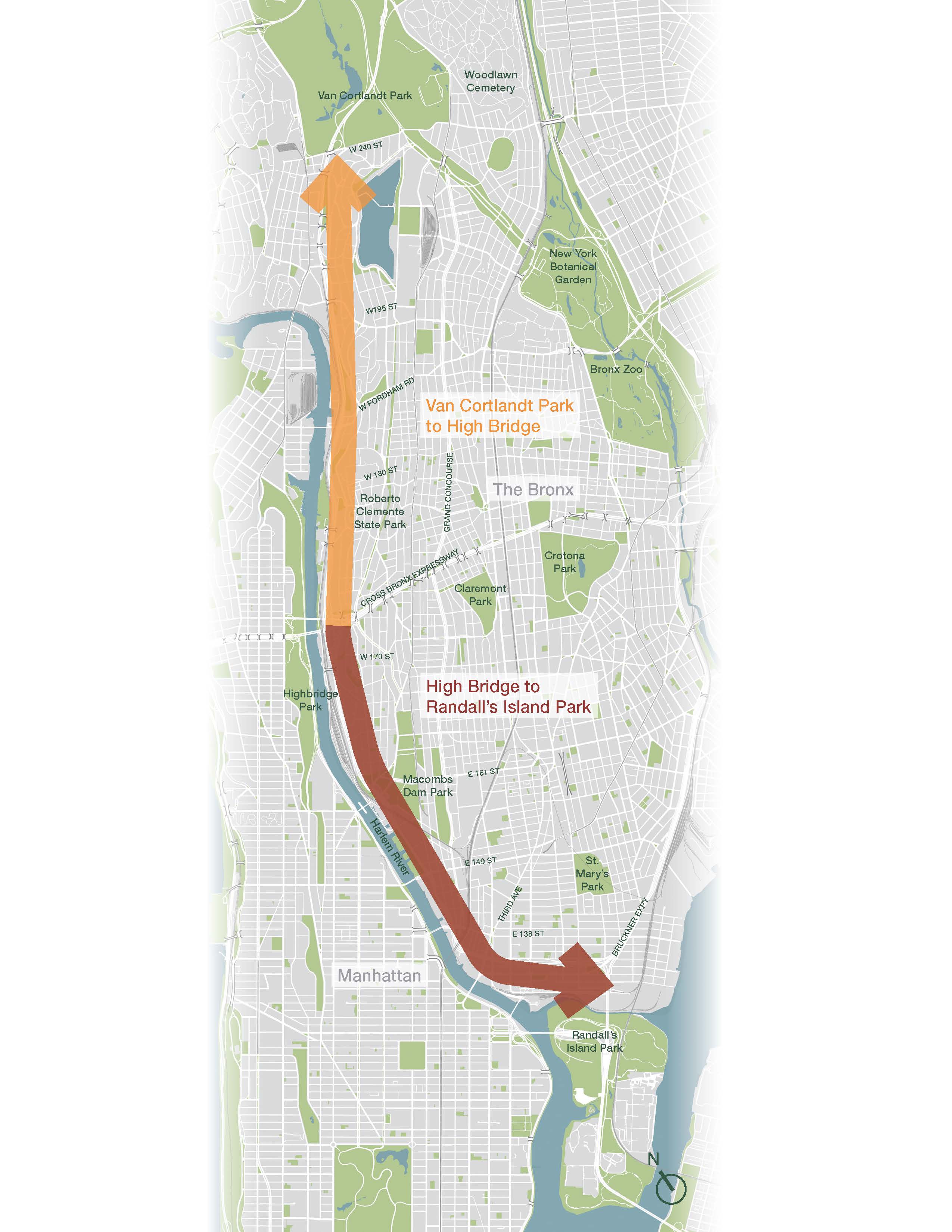
The New York City Department of Transportation (NYC DOT) will host the third and final round of Harlem River Greenway engagement as the city develops an implementation plan for the seven-mile cycling and walking route and new open space from Van Cortlandt Park to Randall’s Island Park. As the culmination of more than two years of community engagement and planning alongside New York City Parks & Recreation and the Economic Development Corporation, NYC DOT will unveil the full proposed route as well as a series of projects for the greenway. The events will consist of a brief presentation followed by an open house where participants can discuss greenway projects with Department of Transportation planners.
-
Monday, March 24: 6-8pm, the Bronx Ale House, 216 W 238th St, Bronx, NY 10463
-
Tuesday, April 1: 6-8pm, the Bronx Brewery, 856 E 136th St, Bronx, NY 10454
-
Monday, April 7: 6-8pm, on Zoom
You can view the presentation from these events here.
Harlem River Greenway (Bronx) Public Workshops
Round 2: Route Alternatives (Spring 2024)
After a year of research and outreach, NYC DOT is returning to the Bronx to gain community members' feedback on our proposed route alternatives to connect Van Cortlandt Park to Randall's Island. As we continue the planning process, we want to ensure our plan reflects the community's priorities.
We will host four workshops (two in-person and two virtual) in March and April 2024 to gather community feedback. You can register to attend below:
Wednesday, March 13, 6:00-8:00pm at Bronx Community College, Roscoe Brown Student Center, Room 211 (Van Cortlandt Park to the High Bridge)
View the presentation from the March 13 workshop.
Tuesday, March 19, 6:00-8:00pm at Bronx Brewery (The High Bridge to Randall's Island Park)
View the presentation from the March 19 workshop.
Wednesday, April 3, 6:00-8:00pm (Virtual) (Van Cortlandt Park to the High Bridge)
Monday, April 8, 6:00-8:00pm (Virtual) (The High Bridge to Randall's Island Park)
Harlem River Greenway (Bronx) Online Public Workshops
Round 1: Existing Conditions (Spring 2023)
NYC DOT is initiating a planning process to develop a 7-mile Harlem River Greenway in The Bronx, creating a continuous walking and cycling connection between Van Cortland Park and Randall’s Island. The implementation plan will aim to better connect Bronxites to their waterfront and provide a critical north-south bike commuting corridor. Bronxites will help shape the plan through a community-based process, which began with three online public workshops in April 2023.
Each workshop collected community feedback focused on existing conditions within the geographic area of three potential greenway segments:
Tuesday, April 18th, 6-8PM: Van Cortlandt Park to University Heights Bridge
View the presentation from the April 18 Workshop.
View the presentation from the April 18 Workshop in Spanish.
Wednesday, April 19th, 6-8PM: University Heights Bridge to Macombs Dam Bridge
View the presentation from the April 19 Workshop.
View the presentation from the April 19 Workshop in Spanish.
Wednesday, April 26th, 6-8PM: Macombs Dam Bridge to Randall’s Island Connector
View the presentation from the April 26 Workshop.
Background
Bronx communities along the Harlem River are disconnected from the waterfront and have long voiced the desire for a continuous greenway and connection to upland neighborhoods as a priority.
The New York City Department of Transportation (NYC DOT), in partnership with the Department of Parks and Recreation, The New York City Economic Development Corporation, and the Department of Environmental Protection, is currently undertaking a community-based process to develop a plan for closing the gaps in the Harlem River Waterfront Greenways in the Bronx. The Harlem River Greenway—when complete—will be a continuous 7-mile transportation corridor connecting Van Cortlandt Park to Randall’s Island.
About the Harlem River Greenway Implementation Plan
-
The Harlem River Greenway Implementation Plan will outline a comprehensive strategy to create a continuous and accessible path by identifying a series of short-term and long-term projects along the Harlem River.
-
NYC DOT is working with community members to identify and address high priority gaps through Street Improvement Projects, building support for larger capital projects and momentum for the entire plan.